Exclusively optimized for desktops.
Geologia Avventurosa
Expertize
Finding Inspiration in Every Turn
A comprehensive portfolio of work undertaken from 2007 to the present, encompassing a wide array of professional and academic activities within the fields of geographical and geological sciences. This portfolio includes detailed geographical analyses, in-depth geological surveys, high-precision cartographic representations, and satellite remote sensing, with a particular emphasis on the refinement of image resolution through the application of advanced software tools.
Furthermore, accompanying this body of work are several publications of a geographical, geological, and geoethnographic nature, which attest to a sustained commitment to research and the dissemination of knowledge in these domains. Such publications not only enrich the portfolio but also underscore the professional's dedication to producing high-quality scientific content and sharing significant findings with the academic and professional community.
Compendio alla Carta dell'Arcipelago Sardo Corso Isola di San Pietro e le sue isole minori.
ISBN 978-88-92681-79-8
Aut. Nicola Borghero
May 2017
Youcanprint
1° edition
The present work aims to analyze and describe the map of San Pietro Island and its minor islands, situated within the Sardo-Corsican archipelago. The analysis encompasses various dimensions, including geographical, urban, historical, cultural, and ethnographic aspects. Complementing the research and cartographic representation, a specific coding system has been developed for the identification of points of interest, as highlighted in the work of Nicola Borghero concerning the City of Carlo Forte (2017). This methodological approach enables systematic cataloging and more effective utilization of the geographical and cultural information associated with these locations.

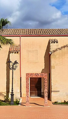
Works for the Jubilee of the Opening of the Holy Door 2016 at the Sanctuary of Santa Greca Martire of the Parish of Sant'Antonio Abate.
Aut. Nicola Borghero
May 2016
Correct road map of the City of Decimomannu for the commemoration of the Jubilee of Mercy
1° edition
The design and implementation of the road map of the city of Decimomannu were carried out in conjunction with the commemoration of the opening of the Holy Door at the Sanctuary of Santa Greca. In this context, a geo-petrographic consultancy role was undertaken for the artist Armandì, aimed at the creation of the artwork "The Portal in Trachyte of Fordongianus," which adorns the side door of the sanctuary. This project required an in-depth analysis of geographical and geological data, as well as the application of advanced cartographic techniques to ensure an accurate and functional representation of the access routes to the sacred site.